CAPE MAY — The city has received a draft of the remedial work plan from Jersey Central Power and Light (JCP&L) to clean up some of the toxic materials at the former Manufactured Gas Plant (MGP) on Lafayette Street between the elementary school and St. John’s Street.
Cape May signed a settlement and access agreement that will eventually allow the city to purchase properties from JCP&L: the former South Jersey gas lot, former Elsie Wise house, corner of Lafayette and St. John’s street and former lodge property on St. John’s Street. JCP&L will have continuing access to the properties.
The city envisions creating a park along Lafayette Street including the former Vance’s Bar property. That is years in the future.
JCP&L needs approval of the state Department of Environmental Protection for its remediation plan that includes construction of two underground containment walls and a series of below surface chambers to filter contaminated groundwater on the site.
The remedial work plan, which is available at the city clerk’s office, outlines a Preliminary Remedial Action Schedule. It projects that DEP began to analyze JCP&L’s proposal last month with an answer from the agency expected by July 1, 2011.
The schedule projects the permitting process lasting from September 2011 to February 2012.
First season construction of underground containment structures is projected to begin in October 2012 and conclude by May 2013. Second season construction is projected to begin in October 2013 and conclude in May 2014.
Third season construction is projected to begin in October 2014 and conclude in May 2015. Operations and maintenance of the remediation system would begin in May 2014 and run until May 2019. Cost of the project is estimated at $7 million to $8 million.
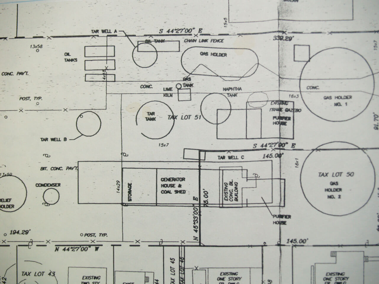
The MGP operated in Cape May from 1853 to 1937 producing gas made by processing coal, which was used by customers for lighting, heating and cooking. The MGP left behind in the ground coal tars, benzene and naphthalene among other toxic chemicals. The gas plant site was inherited by JCP&L, which is responsible for a cleanup of the site.
JCP&L has been conducting environmental investigations on the site since 1985.
The report names three Areas of Concern (AOCs).
AOC1 is in the area of the corner of St. John’s and Lafayette streets and down St. John’s Street, which includes homes. On properties on St. John’s Street, coal tar and other residual products were found at a depth of 20 to 40 feet below the ground surface from soil borings.
Some soil there has been found to contain benzene, styrene, and polycyclic aromatic hydrocarbons (PAH).
GZA Environmental worked in AOC1 from 2000 to 200 excavating soil to a depth of two to six feet, installing a geotextile liner and backfilling with clean fill dirt.
AOC2 is a forested wetlands transition zone where some soil has been found to contain benzene, styrene and PAHS.
AOC3 is the former MGP site where soil has been found to contain benzene, xylenes, styrene and PAHs.
AOC4 is a coastal wetlands where soil was found to contain Benzene and PAH’s.
The report includes “Groundwater Constituents of Concern” and indicates benzene and naphthalene plumes in the shallow and deep groundwater across all four Areas of Concern.
Analytical data indicating exceedances of DEP Ground Water Quality Standards (GWQS) for benzene and naphthalene were used to identify the extent of MGP-related constituents in shallow and deep groundwater from a McLaren/Hart report in 2000.
Benzene concentrations in monitoring well samples in exceedance of the GWQS range from 3.4 micrograms per liter at Monitoring Well 21B to 7,200 micrograms at Monitoring Well 10.
Naphthalene concentrations in monitoring well samples in exceedance of the GWQS range from 410 micrograms per liter at Monitoring Well 9 to 8,100 micrograms per liter at Monitoring Well 10.
Benzene exceedances have been detected offsite at Monitoring Well 21B at 3.4 micrograms per liter, approximately 1,100 feet northwest of the MGP site.
Naphthalene exceedances have been detected approximately 600 feet northwest of the site. A large portion of the plume is located deep in the groundwater zone approximately 25 to 40 feet below the ground surface, which flows to the northwest.
An upward groundwater flow from the deep zone to shallow zone has been observed in monitoring well clusters 18, 21 and 22 in the vicinity of Cape Island Creek.
Groundwater in the shallow zone, ground surface to approximately 25 feet below ground surface, also flows to the northwest before discharging into Cape Island Creek.
Plans call for a vertical barrier to be installed all along the perimeter of the gas plant which would extend from just below the surface and tie into the clay layer about 55 feet below the ground. That would include active pumping and treating, so once the wall is in place, the encapsulated area will be lower than the groundwater level.
A crane-operated auger will install the wall and as the auger is withdrawn from the ground, a material such as Bentonite mixed with cement will be injected into the ground.
Five subsurface vaults, about 10 feet by feet, will be filled with a granular, activated charcoal which groundwater will flow through and remain until contamination is gone.
A secondary containment wall will extend into the wetlands and beyond and cause groundwater to pass through treatment zones. The secondary containment area will stretch from behind the former Vance’s Bar property, south to an area behind a Cape Housing Authority apartment building near St. John and Broad streets.
The report notes based on DEP comments, a supplemental groundwater investigation of the deep aquifer was completed in 2008. Sampling results showed non-detect of chemicals of concern and therefore no remediation is required for deep aquifer.
To evaluate the potential that underground structures potentially containing substantial quantities of MGP materials remain onsite, a geophysical survey was performed on Nov. 29, 2009. The survey was conducted by Enviroprobe using a cart-mounted GPS unit, a metallic locator, a radio detection unit and a Geonics EM31-MK2, which maps subsurface features by changes in conductivity.
Equipment was used to scan the area within the footprint of the proposed Primary Containment Wall. The survey identified a “metallic anomaly” approximately 11 feet by 11 feet and estimated to be approximately 4 feet below the ground near the tennis courts at Wise-Anderson Park.
Plans call to excavate the area and remove what is believed to be an underground storage tank.

Wildwood Crest – In NY City there are hundreds of "migrants" from Africa protesting because the housing and food they are given is not good enough. They say they deserve better. Their representative went in…